

The two Road bridges of Pentlow
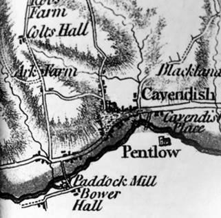
There has long been a road bridge at Cavendish. The only problem has been in working out where. In fact, the main coaching route south has varied a great deal over the years between two river crossings. The first was at Paddock (Padbrook) Mill, and the second at Pentlow Hall.
The siting of river crossings is important. The Stour between Haverhill and Long Melford represents the Essex-Suffolk border, and the edge of East Anglia. It can generally be waded in summer, but can be very different in a rainy spell, especially in the winter, and there are records of deaths when attempting to travel via the ford between Pentlow Mill and Pentlow Hall.
The first depiction of the river bridge at Pentlow is on Spede’s map of 1575. There are three crossings shown: at Clare, Pentlow and Sudbury. The Pentlow crossing seems to be of some importance, ranked as it was alongside the bridges of Clare and Sudbury. At the time that this map was made, Cavendish was already important as a coaching stop. There were coaching inns and a prominent pond on the edge of the road for horses, and for moistening the wheels of the coaches and carts. The Cambridge route was important, but the route south to Castle Hedingham was favoured.

These bridges are repeated in other later maps, but not in Van Den Deere’s map of 1603

... r William Morgan’s “Essex Actually Surveyed” of 1678.

None of the maps at this stage tell us anything about the roads used. The first accurate road map I know of is that of 1724.

This shows the itinerary of the route south to Castle Hedingham and Halsted, and thence by the old roman road to Braintree and London. The alternative route was via Clare. The itinerary was probably copied onto the map from a printed itinerary for it is careful in marking the road junctions. You can identify these road junctions on the modern map and they are surprisingly accurate. Some parts of this route are now very narrow lanes. The bridge crossings correspond to Spede’s map, 150 years previous.
The road via Paddock Mill seems, at this time, to be the only one, though the bridge at Pentlow Hall is marked. The halls, such as Bower Hall, that are marked on the map are there not just because they are splendid, but because they are important guides for the traveller to make sure he is still on the right road.

J Carey’s 1794 road map shows clearly that there was no route over the Pentlow Bridge and the main bridge was at Paddock Mill.

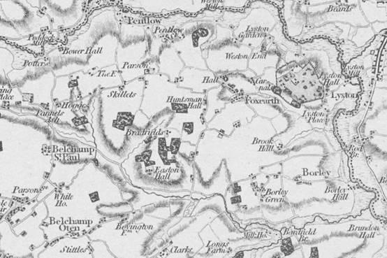
We can see this also on the first detailed map of the area done by Chapman and Andre in 1777…
This confirms the accuracy of the sketch map done of Cavendish in 1793, which gives detail of the two bridges. The main one at Paddock Mill …

... where it shows clearly that the heavy carts had to run through the river for several yards before emerging on the other bank. At this time, the bridge is definitely narrowed but it is in a different place to the modern footbridge.

The other bridge at Pentlow is clearly shown on the map too.
A 1794 map shows that the Paddock Mill bridge was the only through route in use at the time. It would seem that the bridge to Pentlow wasn’t usable at this time.
Curiously, The first Ordnance Survey map of 1790 shows no bridge at what it wrongly calls ‘Puddock mill’.
Hodgkisson’s map, done just ten years earlier, shows the bridge, though.
A map of 1794 shows only the Paddock Mill bridge.

Carey’s 1840 map shows both routes in use, with the Paddock Mill Bridge clearly dominant.

This is confirmed by Pigot’s 1840 map.
What does all this tell us? Firstly, you should never trust a map. Even contemporary maps can tell a contradictory story. However, we can conclude that the Paddock Mill river crossing was once an important crossing way that rivalled the great iron bridge at Clare and Ballingdon Bridge. Pentlow Bridge, on the other hand, didn’t feature in many people's mind as a good place to cross the river until the present great brick bridge was built in 1880. It is hard nowadays to visit Paddock Mill (now called Cavendish mill since the days when it was a restaurant) and in its peaceful quiet surroundings, to imagine the times when coaches dared to use the old wooden bridge to get to Essex.
The siting of river crossings is important. The Stour between Haverhill and Long Melford represents the Essex-Suffolk border, and the edge of East Anglia. It can generally be waded in summer, but can be very different in a rainy spell, especially in the winter, and there are records of deaths when attempting to travel via the ford between Pentlow Mill and Pentlow Hall.
The first depiction of the river bridge at Pentlow is on Spede’s map of 1575. There are three crossings shown: at Clare, Pentlow and Sudbury. The Pentlow crossing seems to be of some importance, ranked as it was alongside the bridges of Clare and Sudbury. At the time that this map was made, Cavendish was already important as a coaching stop. There were coaching inns and a prominent pond on the edge of the road for horses, and for moistening the wheels of the coaches and carts. The Cambridge route was important, but the route south to Castle Hedingham was favoured.
These bridges are repeated in other later maps, but not in Van Den Deere’s map of 1603
... r William Morgan’s “Essex Actually Surveyed” of 1678.
None of the maps at this stage tell us anything about the roads used. The first accurate road map I know of is that of 1724.
This shows the itinerary of the route south to Castle Hedingham and Halsted, and thence by the old roman road to Braintree and London. The alternative route was via Clare. The itinerary was probably copied onto the map from a printed itinerary for it is careful in marking the road junctions. You can identify these road junctions on the modern map and they are surprisingly accurate. Some parts of this route are now very narrow lanes. The bridge crossings correspond to Spede’s map, 150 years previous.
The road via Paddock Mill seems, at this time, to be the only one, though the bridge at Pentlow Hall is marked. The halls, such as Bower Hall, that are marked on the map are there not just because they are splendid, but because they are important guides for the traveller to make sure he is still on the right road.
J Carey’s 1794 road map shows clearly that there was no route over the Pentlow Bridge and the main bridge was at Paddock Mill.
We can see this also on the first detailed map of the area done by Chapman and Andre in 1777…
This confirms the accuracy of the sketch map done of Cavendish in 1793, which gives detail of the two bridges. The main one at Paddock Mill …
... where it shows clearly that the heavy carts had to run through the river for several yards before emerging on the other bank. At this time, the bridge is definitely narrowed but it is in a different place to the modern footbridge.
The other bridge at Pentlow is clearly shown on the map too.
A 1794 map shows that the Paddock Mill bridge was the only through route in use at the time. It would seem that the bridge to Pentlow wasn’t usable at this time.
Curiously, The first Ordnance Survey map of 1790 shows no bridge at what it wrongly calls ‘Puddock mill’.
Hodgkisson’s map, done just ten years earlier, shows the bridge, though.
A map of 1794 shows only the Paddock Mill bridge.
Carey’s 1840 map shows both routes in use, with the Paddock Mill Bridge clearly dominant.
This is confirmed by Pigot’s 1840 map.
What does all this tell us? Firstly, you should never trust a map. Even contemporary maps can tell a contradictory story. However, we can conclude that the Paddock Mill river crossing was once an important crossing way that rivalled the great iron bridge at Clare and Ballingdon Bridge. Pentlow Bridge, on the other hand, didn’t feature in many people's mind as a good place to cross the river until the present great brick bridge was built in 1880. It is hard nowadays to visit Paddock Mill (now called Cavendish mill since the days when it was a restaurant) and in its peaceful quiet surroundings, to imagine the times when coaches dared to use the old wooden bridge to get to Essex.
posted by Andrew Clarke | 7:36 pm
|
0 comments
![]()